Index
This topic area covers statistics and information relating to the Hull’s physical geographical area and some information relating to the environment including local strategic need and service provision. Further demographic, health and wellbeing information relating to specific geographical areas such as electoral wards under Ward Profiles within Place. Further information on the environmental factors of Air Pollution and Climate Change can be found within Health and Wellbeing Influences.
More information relating to the population differences between the NHS geography (based on patients registered with Hull GPs) and the local authority (based on residents of Hull) and the difference in these estimates from different data sources is given on Population Estimates under Population. Further information on the differences in the type of housing and household composition within Hull can be found on Housing and Households under Health and Wellbeing Influences.
This page contains information from the Office for Health Improvement & Disparities’ Fingertips. Information is taken ‘live’ from the site so uses the latest available data from Fingertips and displays it on this page. As a result, some comments on this page may relate to an earlier period of time until this page is next updated (see review dates at the end of this page).
In July 2022, Clinical Commissioning Groups (CCGs) ceased to exist and were replaced by the Integrated Care System. Data will still be available at CCG level for some time after July 2022 so the JSNA will continue to reference CCGs and Hull CCG as well as the larger geographical area Humber, Coast and Vale which included Hull CCG. New data is becoming available for Hull’s Health and Care Partnership and is referred to as sub Integrated Care Board and referenced by 03F for Hull within Fingertips, as well as data being available for the larger local geographical area – the Humber and North Yorkshire Health and Care Partnership or Humber and North Yorkshire Integrated Care Board.
Headlines
- The geographical boundaries in Hull are tight and exclude the more affluent suburban areas unlike other cities. This means that Hull is ranked among the most deprived local authorities in England.
- Hull is 71.6 kilometres square and has around 4,000 residents per square kilometre. Hull is in the top 15% of lower-tier local authorities with the highest population density.
- It is likely that some people in Hull move to the ‘leafy suburbs’ in East Riding of Yorkshire just outside Hull’s boundary each year. The more aspirational, successful and motivated people will tend, on average, to have increased mobility, and this affects the employment and skills profile of Hull.
- Owing to Hull’s somewhat isolated location, people may be less likely to be influenced by positive health factors occurring elsewhere.
- The geographical boundaries for Hull local authority are the same as for Hull’s Health & Care Partnership (sub Integrated Care Board area), although the population size if different. The estimate resident population was 268,852 people from the Office for National Statistics mid-year 2022, but the number of patients registered with Hull GPs was over 314,000 patients as at January 2024 (and around 8% of these patients live in East Riding of Yorkshire). Furthermore, the GP registration file includes almost 24,000 ‘extra’ residents compared to the Office for National Statistics resident population estimates (8% of total residents in the registration file). Some of these ‘extra’ residents are likely to be ‘ghost’ patients who are have moved away but have not registered with another GP in England (either because they haven’t been ill since moving or they moved abroad – some of which may have been students).
The Population Affected – Why Is It Important?
In order to improve health and reduce inequalities, it is important to understand the make-up of the local population, the geographical area and the environment. Features within the geographical areas, such as rivers or the location of residential, commercial and industrial areas, or the way in which boundaries have been derived can all influence the health needs of the local population, and also their access to services.
As the World Health Organisation states “Humans interact with the environment constantly. These interactions affect quality of life, years of healthy life lived, and health disparities.” WHO defines environment, as it relates to health, as all the physical, chemical, and biological factors external to a person, and all the related behaviours. From Healthy People 2020, environmental health consists of preventing or controlling disease, injury, and disability related to the interactions between people and their environment.
The World Health Organisation estimate that 24% of the global disease burden and 23% of all deaths can be attributable to environmental factors, and that this figure is higher for children aged 0-14 years (36% for deaths). The overall figures are lower in high income countries and it is estimated that this figure is around 14% on average in Europe in relation to deaths. However, there are large inequalities both between and within countries.
Environmental factors include indoor and outdoor air pollution, climate change, extreme weather events, flooding, drought, unsafe drinking water, chemical and radiation exposures, leaks and contaminations including contaminated land, exposure to lead, asbestos and other substances and chemicals, exposure to other adverse substances in the home such as mould, noise pollution, light pollution, and a number of other environmental factors.
While Hull has a very good air quality story so far, air pollution is a major cause of premature death and disease, and is the single largest environmental health risk in Europe according to the European Environmental Agency.
The Intergovernmental Panel on Climate Change state that we are currently experiencing the greatest change in the natural environment in human history. The threat of climate change as a result of the increase of greenhouse gases by human activity is pushing known planetary boundaries in areas such as species loss, air quality, natural resources and extreme weather events. The increasing global population expansion and dietary change is putting pressure on agriculture and land use.
As stated by the government, the transition to a low carbon society to combat these environmental threats provides challenges in energy generation and its use, urban transport to combat air quality and improve physical health and improving the resilience and adaptability of our communities particularly the most vulnerable.
The Hull Picture
About Hull
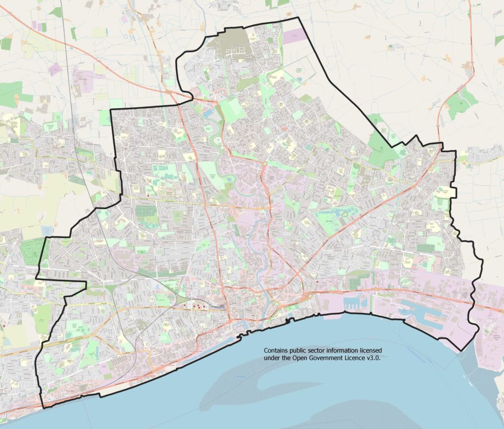
The city and port of Hull lies on the banks of the River Humber and is positioned at the gateway to Europe. It is linked to the national motorway networks from the west via the M62 and to the south across the Humber Bridge via the M180. Hull is surrounded by the East Riding of Yorkshire, a largely rural area containing a number of suburbs immediately adjacent to the city.
Hull has some outstanding cultural and historic assets, many of national and international significance. Green space makes up around a third of land use (34.4%), followed by domestic gardens (20.6%), roads (13.0%), domestic buildings (8.6%), non-domestic buildings (6.4%), water (2.5%), paths (1.6%) and rail (0.6%), with the remaining 12.3% defined as other land uses. Hull is a total of 7,154 hectares.

Since Hull was announced as the UK’s City of Culture 2017, numerous multi-million pound investments have revitalised and transformed the city centre. Investments of more than £1 billion have flowed into the city, creating thousands of jobs, and over £3 billion in total from public and private investment. Thousands of volunteers helped deliver the cultural programme in 2017 with nine in ten people in Hull taking part in City of Culture events. Visitor numbers increased dramatically. Following on from its success, the City of Culture legacy has been embedded in every stage of the UK City of Culture journey and has been the topic of the 2016 Director of Public Health Annual report with a ten-year Cultural Strategy 2016-2026 launched in a bid to sustain the economic boom and “put culture and the arts at the heart of Hull’s regeneration and development”.
Hull’s Tight Geographical Boundaries
In relation to the characteristics of Hull, one problem relatively unique to Hull is its tight geographical boundaries. Most cities such as Hull are relatively deprived, but most other local authority or NHS boundaries include some more affluent suburban areas. Hull has very few affluent suburbs within its boundaries, and it is estimated that a number of people in Hull move to the ‘leafy suburbs’ in East Riding of Yorkshire just outside Hull’s boundary each year. The people that tend to move will often do so because of children and better schools, better quality and choice of housing, etc. The more aspirational, successful and motivated people will tend, on average, to have increased mobility. This also affects the employment and skills profile of Hull. Furthermore, owing to Hull’s somewhat isolated location, people may be less likely to be influenced by positive health factors and changes occurring elsewhere in other geographical areas. Due to Hull’s high levels of deprivation and tight boundaries, Hull is often at the bottom of national league tables and among the ‘worst’ for various indicators for both health and the wider determinants of health. As a result, there are often negative comments made about Hull, which can influence attitudes, health and lifestyle. Within local qualitative research projects, there were certainly some residents that had a “what’s the point?” attitude with regard to their health and lifestyle changes, however, others felt that this was just an excuse “You can lead a healthy lifestyle anywhere, it’s not the place – I staunchly defend Hull– it’s about choices”.
From the Office for National Statistics population estimates for 2022, Hull is 71.6 kilometres square and has an estimated 3,756 residents per square kilometre. Hull is in the top 15% of lower-tier local authorities in terms of having high population density.
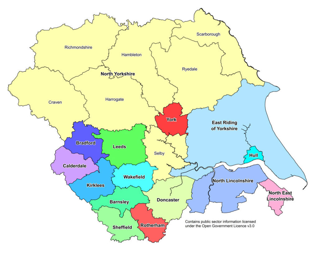
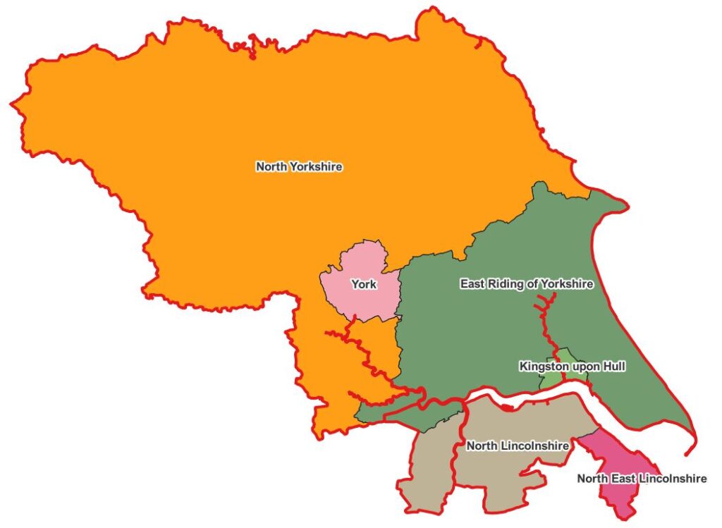
Hull’s Location Within the Yorkshire and Humber Region
Hull is one of 15 County and Unitary Authorities, and one of 21 District Authorities in the Yorkshire and Humber region (North Yorkshire County Authority is split into seven District Authorities).

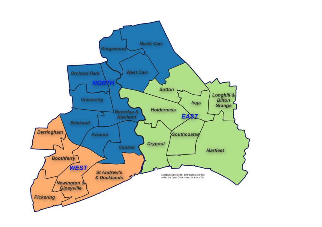
Hull’s Electoral Wards
There were 23 wards in Hull prior to May 2018 and this had been the case for more than a decade. In May 2018, the number of wards in Hull reduced to 21, and the boundary of every single ward changed. Some changes were relatively minor, but other changes were much more substantial. The names of around half of the wards remained the same despite changes to all the boundaries. These also ranged from relatively minor changes to entirely new names for some wards. Prior to April 2023, Hull was divided into seven Area Committee Areas each covering three wards with North Carr, Kingswood, and West Carr in Foredyke Area, Beverley & Newland, Orchard Park, and University in Northern Area, Ings, Longhill & Bilton Grange, and Sutton in East Area, Holderness, Marfleet, and Southcoates in Park Area, Drypool, Newington & Gipsyville, and St Andrew’s & Docklands in Riverside Area, Boothferry, Derringham, and Pickering and West Area, and Avenue, Bricknell, and Central in Wyke Area.
As at April 2023, there are three Area Committee Areas as illustrated in the map below.

Geographical Boundaries Relating to the NHS
The other key geographical boundary for Hull in terms of health relate to those associated with the NHS. Prior to April 2013, the NHS comprised of Primary Care Trusts (PCTs), and between April 2013 and June 2022, the local NHS geographical area was made up from Clinical Commissioning Groups (CCGs). There were also Sustainability and Transformational Partnerships (STPs) made up of a number of local CCGs. Prior to July 2022, Hull was included within the Humber, Coast and Vale (HCV) STP (which included five other local CCGs: North Yorkshire, Vale of York, East Riding of Yorkshire, North Lincolnshire and North East Lincolnshire). The STPs were later transformed into Health and Care Partnerships (HCPs), and there have been further changes to the NHS geography in July 2022 with Integrated Care Systems.
The Integrated Care System (ICS) is made of up two core statutory elements at system level formerly came into effect on 1 July 2022 when CCGs ceased to exist. The ICSs are where major decisions are made, and overarching strategies agreed. The Integrated Care Boards (ICB) replace CCGs and are focused on the core NHS services, with responsibilities including NHS funding, commissioning and workplace planning. The Integrated Care Partnerships (ICP) have a broad focus, covering ICB-wide strategy, public health, social care, and wider issues impacting the health and wellbeing of the population. There will continue to a Place element within the ICS, and this will involve the planning of localised services and secondary and community care. NHS England sees ‘place’ as the key driver of change within ICSs and they are expected to be where the majority of work actually occurs. Data will continue to available at CCG level for some time and as a result CCG will still be referenced within our Joint Strategic Needs Assessment, and will gradually be replaced over time as the new system is embedded and new data becomes available at the new geographical levels.
The Office for Health Improvement & Disparities’ Fingertips includes some information at sub-ICB level, and Hull is referenced by its CCG code of 03F.
All areas within the Humber and North Yorkshire Integrated Care Board are:
- 02Y – East Riding of Yorkshire
- 03F – Hull
- 03H – North East Lincolnshire
- 03K – North Lincolnshire
- 03Q – Vale of York
- 42D – North Yorkshire
Hull’s Place element is Hull’s Health and Care Partnership, and the Humber, Coast and Vale Health and Care Partnership also ceased to exist and Hull is included in the Humber and North Yorkshire Health and Care Partnership or the Humber and North Yorkshire Integrated Care Board.
The geographical boundary of the local authority is the same as the boundary for the NHS in Hull, although the population size if different. The resident population is estimated to be 286,852 people in 2022, but the number of patients registered with Hull GPs in January 2024 is 314,119 patients (and around 8% of these patients live in East Riding of Yorkshire). For more information about the difference between the resident population and registered population, see Population Estimates under Population.

Percentage Visiting Natural Environment For Health or Exercise Purposes
The Office for Health Improvement & Disparities’ Fingertips gives an estimate of the percentage of people who have taken a visit to the natural environment for health or exercise purposes over the previous seven days. The information has not been updated so is quite out-of-date, but nevertheless gives an indication of the utilisation of outdoor space and comparison with other local authorities across the region. Furthermore, these percentages could well have changed both during and after the COVID-19 pandemic.
Compared with benchmark
| Indicator | Period | England | Yorkshire and the Humber region (statistical) | Kingston upon Hull | East Riding of Yorkshire | North East Lincolnshire | North Lincolnshire | York | Barnsley | Doncaster | Rotherham | Sheffield | Bradford | Calderdale | Kirklees | Leeds | Wakefield | North Yorkshire Cty |
|---|---|---|---|---|---|---|---|---|---|---|---|---|---|---|---|---|---|---|
Utilisation of outdoor space for exercise or health reasons (Persons 16+ yrs) | Mar 2015 - Feb 2016 | 17.9 | 17.5 | 18.0 | 16.8 | 22.0 | 6.4 | 20.9 | 14.5 | 19.3 | 13.5 | 15.3 | 12.4 | 20.4 | 17.6 | 20.5 | 16.6 | 17.8 |
Fingertips also provides information on the trends over time relating to this indicator prior to this indicator finishing in 2016. The percentages in Hull were lower than England for the four periods 2011-12 to 2014-15 but in the last reporting period of 2015-16, the percentage in Hull was slightly higher than England.
Compared with benchmark
Utilisation of outdoor space for exercise or health reasons (Persons 16+ yrs)
|
Period
|
Kingston upon Hull |
Yorkshire and the Humber region (statistical)
|
England
|
||||
|---|---|---|---|---|---|---|---|
|
Count
|
Value
|
95%
Lower CI |
95%
Upper CI |
||||
| Mar 2011 - Feb 2012 | • | - | 11.7% | 8.1% | 15.2% | 15.2% | 14.0% |
| Mar 2012 - Feb 2013 | • | - | 11.0% | 7.5% | 14.6% | 16.5% | 15.3% |
| Mar 2013 - Feb 2014 | • | - | 13.0% | 9.5% | 16.4% | 18.3% | 17.1% |
| Mar 2014 - Feb 2015 | • | - | 14.3% | 10.8% | 17.8% | 19.4% | 17.9% |
| Mar 2015 - Feb 2016 | • | - | 18.0% | 14.0% | 22.0% | 17.5% | 17.9% |
Source: Office for Health Improvement and Disparities (OHID)
Environmental Factors
Further information on the environmental factors of Air Pollution and Climate Change can be found within Health and Wellbeing Influences.
Strategic Need and Service Provision
Most of the above factors in terms of physical and organisational boundaries are fixed and not amenable to change. However in the absence of altered local authority boundaries, they reinforce the need for close and collaborative working with local geographic partners, particularly in the East Riding of Yorkshire, and areas included within the the Humber and North Yorkshire Health and Care Partnership. The upside of Hull’s tight boundaries is that access to central services in Hull City Centre is relatively good for the majority of the public, with good transport links radiating to and from the City Centre. Links such as bus routes are often less good between communities “around the edge” of Hull, which may be physically near to one another but not have easy access.
The aim of the Humber and North Yorkshire Health and Care Partnership is to work together to help everyone have the best start in life, live well and grow older well. Making sure that every child has the best start in life, making sure that everyone can access the right care and support when their health changes, supporting people to be independent and in control as they get older, and making sure that people can talk about what they want to happen when when they die. Their priorities are as follows:
- Helping people to look after themselves and stay well;
- Making sure services are joined across health and care;
- Making sure we have the right care in certain areas; and
- Making sure we are using our resources well.
The Humber and North Yorkshire Health and Care Partnership’s approach may be different across the different geographical areas depending on the characteristics within each area.
There has been significant recent investment in Hull revealed within Hull’s City Plan both before, during and after the City of Culture year of 2017.
The ambitions of the Hull’s City Plan are to make Hull the leading hub for renewable energy industries (UK Energy City), make Hull a world-class visitor destination (Destination Hull) by capitalising on Hull’s role as UK City of Culture 2017, the multi-million pound investment into the city’s cultural and tourism infrastructure, and making Hull a place of opportunity for all, building strong and resilient communities by focusing on safeguarding the most vulnerable, prevention and early intervention, and making money go further (Community and Opportunity). Significant progress has already been made in these areas, and it is necessary to ensure that this momentum is built upon and developed within the wider context of the need to de-carbonise the economy to reduce the impact of climate change and ensure effective resilience to climate change.
Since January 2013, Hull City Council has held the highest Green Accreditation for its environmental management system, Investors in the Environment and undertaken work to reduce its carbon emissions in line with its corporate targets. It has also undertaken climate adaptation risk assessment for Housing, Museums and Gallery, Waste Management, and Parks and Transport services.
It is necessary to work together to maintain and expand an environment that promotes physical activity and active lifestyle opportunities in everyday settings for all ages. There is also a need to work with partners to ensure the design of the built environment discourages crime and fear of crime.
We need to increase access to traditional environmental spaces including parks, nature areas, gardens, cycle paths, recreational paths and water courses to improve physical and mental well-being and ensure that these are maintained in a sustainable way.
There should be support for sustainable and seasonal approaches to food use within the City to support healthy eating within health and care environments through the Green Kitchen Standard and support residents in cooking and eating healthily.
In terms of improving the environment for the people of Hull, it is important that any measures in the proposed climate change strategy and proposed action plan consider the implications on and as far as possible complement those in the Air Quality Strategy, as some could have a detrimental impact on air quality. For example, monitoring during the COVID-19 lockdown indicates that as direct emissions from vehicles decrease (mono nitrogen oxide and nitrogen dioxide combined) it has the potential to result in an increase in the concentrations of other potentially harmful gases, such as ozone, and only a minimal reduction in the emissions of particulate matter. This has implications and will need to be considered when advocating a change to electric vehicles.
Resources
City Plan. http://www.hull.gov.uk/council-and-democracy/policies-and-plans/hull-city-plan
Ward and Area Committee Area Profiles
Humber and North Yorkshire Health and Care Partnership. https://humberandnorthyorkshire.org.uk/
Updates
This page was last updated / checked on 10 July 2024.
This page is due to be updated / checked in March 2025.